An Atlantic weather system is approaching Italy, bringing increased instability and higher humidity, particularly affecting the Liguria region. Earlier today, thunderstorms were observed over the Ligurian Sea, with some impact on the coastal areas, although the likelihood of severe weather events remains low.
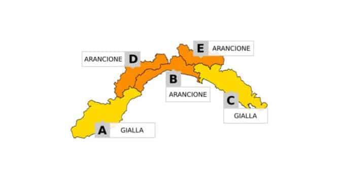
During the afternoon, winds from the east-northeast are expected to strengthen in the eastern part of Liguria. This airflow will meet winds coming from the Po Valley, mainly in the western area, creating conditions that support the continuation of thunderstorms in the central part of the region. As a result, Arpal has issued a warning for thunderstorms with varying levels of severity depending on the location and time. Specifically, the central-western area will experience a yellow alert starting from 9 pm today, which will escalate to an orange alert—the highest level for thunderstorms—during the early hours of tomorrow. Other areas, such as the western and eastern parts, will also be under a yellow alert at different times.
The precise development of the weather events remains uncertain due to the complexity of atmospheric currents. According to meteorological sources (Arpal), the exact localisation of wind convergence and their strength will depend on several factors, including the extent to which the Scirocco wind reaches the Ligurian coast and the precise direction of the breezes. These aspects will only be clearer as the situation unfolds. Additionally, stronger southwesterly winds at higher altitudes might limit the formation of more intense thunderclouds over Liguria, potentially shifting moisture towards the Alps where significant rainfall is anticipated.
Another factor to consider is the expected rise in sea wave activity. Surface winds will contribute to a storm surge forecasted for Friday along all Ligurian coasts. Before this event, tomorrow will be a critical day to monitor the progression of rainfall, which is expected to begin in the central-western area and then move eastwards. The precipitation will be widespread and accompanied by thunderstorms affecting the entire region. Particular attention is being paid to stationary thunderstorms predicted in the early morning and extending into the middle of the day, especially in the central and western parts of Liguria.
In summary, the meteorological situation is characterised by complexity and variability, necessitating careful monitoring by both authorities and the public to respond promptly to any issues arising from the thunderstorms and deteriorating marine conditions.
AREAS AND ALERT TIMES FOR THUNDERSTORMS
BDE AREAS (central-west):
Yellow Alert: from 21:00 on Wednesday 27 August
Orange Alert (highest level): from 00:00 to 15:00 on Thursday 28 August
Yellow Alert: from 15:00 to 18:00 on Thursday 28 August
AREA A (west):
Yellow Alert: from 00:00 to 18:00 on Thursday 28 August
AREA C (east):
Yellow Alert: from 06:00 to 23:59 on Thursday 28 August
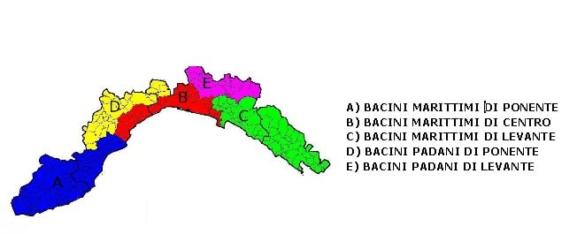
The areas affected in Liguria are divided as follows: Zone A includes the Ligurian Maritime Basins of the West, Zone B includes the Ligurian Maritime Basins of the Centre, Zone C refers to the Ligurian Maritime Basins of the East, Zone D concerns the Ligurian Po Basins of the West, and finally, Zone E includes the Ligurian Po Basins of the East.