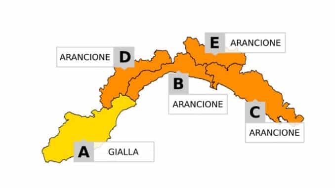
According to the latest weather forecasts, Liguria is expected to experience a significant thunderstorm event tomorrow, 20 August. In anticipation of this weather deterioration, the Regional Agency for Environmental Protection of Liguria (ARPAL) has issued an orange weather alert for thunderstorms, effective from 7 am to 6 pm in the central and eastern parts of the region.
Meteorological models indicate increasing instability beginning in the early hours of the night, with localized thunderstorms that may intensify and become more sustained during the morning. Hail is anticipated, with hailstones ranging between 2 and 4 centimetres in size in some areas, accompanied by strong winds capable of producing phenomena such as waterspouts and tornadoes.
ARPAL’s alert forecasts a yellow level of criticality for thunderstorms throughout Wednesday 20 August, escalating to orange – the highest warning level for these weather conditions – during the central hours of the day, between 7 am and 6 pm, affecting a substantial portion of Liguria from the central area to the east.
The weather situation is expected to be influenced by moist air flowing in from the south-east at ground level, combined with strong south-west winds at higher altitudes. These factors will promote the formation of convergence zones between air masses with differing characteristics, particularly between the Savona area and the eastern part of the region. ARPAL explains that “the convergence of winds represents one of the most dangerous aspects because it feeds and can cause precipitation to remain stationary, worsening the potential impact on the ground affected by the storms or immediately downstream.”
The high humidity throughout all atmospheric layers, together with the arrival of cooler air aloft, creates conditions conducive to the development of intense and well-organised thunderstorms. Nonetheless, weather models still show some uncertainty regarding the precise timing and location of the most severe events, making it difficult to predict exactly where the strongest storms will occur.
The main phase of the disturbance is expected during the night between Wednesday and Thursday, with further updates anticipated as the situation evolves. The most significant impacts are likely to be linked to thunderstorms affecting specific areas rather than the entire region.
Authorities advise the public to stay informed by regularly checking official sources such as the OMIRL portal and the Meteo3r app, which provide real-time data and radar imagery.
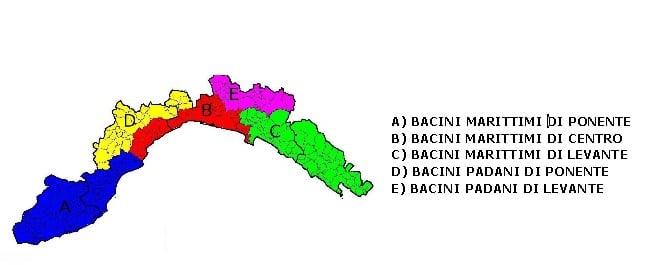
The affected areas in Liguria are divided as follows: Zone A includes the Western Ligurian Maritime Basins, Zone B covers the Central Ligurian Maritime Basins, Zone C refers to the Eastern Ligurian Maritime Basins, Zone D concerns the Western Ligurian Po Basins, and finally, Zone E comprises the Eastern Ligurian Po Basins.